✨Let’s get real and break down real-time information.
What is it? How does it work? How does the actual location of a bus on a route make it to the app you check when planning your trip?
This time on The Next Stop Blog, we caught up with the Customer Information Systems team to find out what real-time information is and how we’re using it to improve your experience.
Keep reading to find out more about recent updates!
Scheduled vs. real-time
There are two kinds of trip information that transit agencies create and share: scheduled time information and real-time information.
Scheduled time is the fixed time assigned to each bus on a route. This information is shared in printed stop schedules at bus stops. Schedules are helpful for planning your trip in advance, but they aren’t always helpful when something happens along your route that causes a delay. For example, traffic, construction, or weather can all lead to a bus showing up late to a stop, and scheduled times can’t account for these kinds of day-to-day fluctuations.

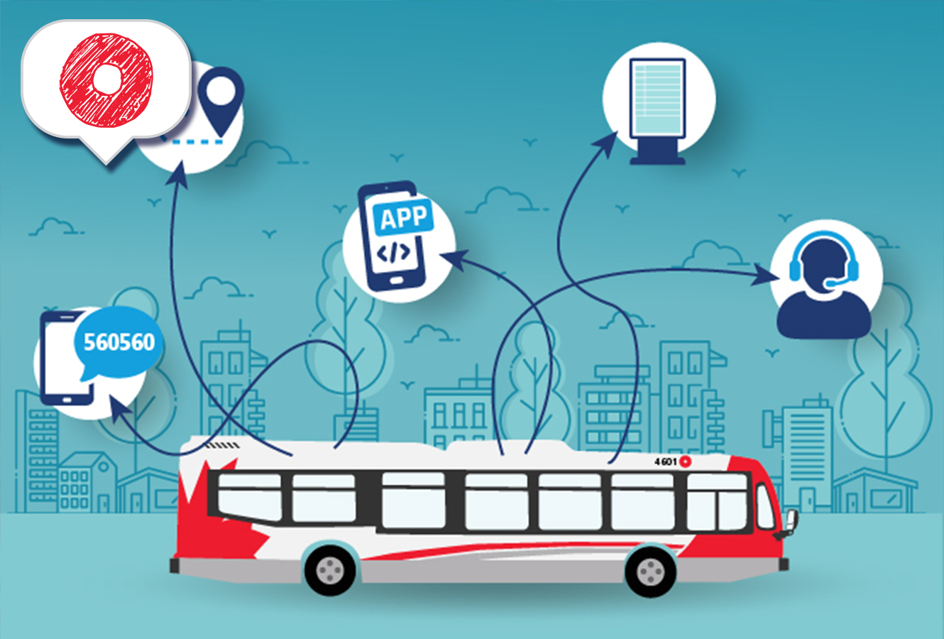
Real-time information shows where the bus is actually located at any given time, not just where it “should” be. You might recognize real-time information as the live information that you see in :
- Transit app,
- the Next Departures tool on octranspo.com,
- a text from 560560,
- Transit Information Screens at stations, and most recently,
- the information given when you call 560-1000, our next departures phone line.
Over the past few years, the Customer Information Systems team has been working hard to improve the quality of OC Transpo’s real-time information.
“Our job is to reduce the steps between data collection and customer trip-planning tools. We’re focused on streamlining the data and getting it out to our customers as fast and in as many ways as possible.”— Lawrence, our Customer Information Systems Program Manager

One of the ways the team is doing this is by leading a transition from API 2.0, OC Transpo’s previous way of formatting real-time information, to General Transit Feed Specification (GTFS).
Introducing GTFS Realtime
In simple terms, GTFS is a way of formatting transit information. Realtime refers to the type of transit information being shared. One of the advantages of this format is that it is an industry standard and widely used. In fact, popular apps like Google Maps and Apple Maps are built specifically for the GTFS format. GTFS Realtime also includes improvements to the quality of real-time information. It shows the status of trips including cancellations and provides vehicle locations for all vehicles along each route.
The Customer Information Systems team provided access to the first version of the GTFS Realtime feed on our Developers page in 2024. This data went through rigorous testing in 2024. Since then, a dedicated team has worked on making more kinds of real-time information available in the feed as well as improving the accuracy of the predictions.
“As any customer will know, reliable real-time information can really improve the experience of taking transit,” said Lawrence. “There will always be reasons for trip delays, but we can make the customer experience better by letting you know about a delay as soon as possible so that you can plan your trip effectively, without leaving things to chance.”— Lawrence, our Customer Information Systems Program Manager
In addition to higher quality data about bus positions, GTFS Realtime also allows information like cancelled trips to be shared more easily. It also introduces predictions for the start of trips.
What can I expect next?
“Our ultimate goal is to integrate GTFS across all our systems at OC Transpo, so that no matter which tools customers choose when they plan their trips, they’ll find accurate and consistent real-time information across each option.”— Lawrence, our Customer Information Systems Program Manager
The latest trip planning tool to make the switch was our 560-1000 next departures phoneline. Now, when you call 613-560-1000 from a bus stop and input your 4-digit stop number, the next departures provided will specify the real-time prediction for upcoming trips within 45 minutes. Cancelled trips will also be indicated.
Meanwhile, we’re also testing out new ways to share real-time information.
You may have heard of the Bus Stop Transit Information Screens that we are currently piloting. These devices use e-paper technology (similar to an e-reader) to share arrival times based on the GTFS Realtime feed. These devices are a new addition to our signage options, and require testing and adjusting, especially during our cold winter months where freezing temperatures can impact performance. Current testing is focused on the connectivity of the devices and monitoring how well the devices communicate with the rest of our system.

The purpose of a pilot project is to test out how new devices would work in the field and to troubleshoot issues over a period of time before putting them into widespread use.
As you travel around the city, keep an eye out for all the different ways that scheduled and real-time transit information is shared. Behind the information is a team hard at work refining and improving the way this data gets to your mobile device and a transit screen near you!