Alerts
Register for alertsDetours / Route changes
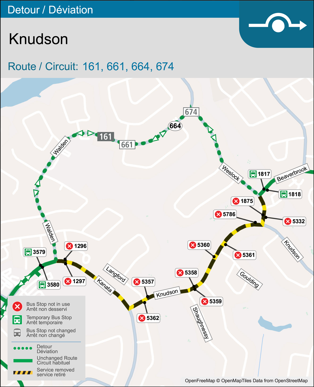
UPDATE—Detour: Route 161 around Knudson Avenue closure (Kanata to Weslock)
Routes: 161
Date effective: April 12, 2026
Detour start and end date, and routes affected have been updated on April 9, 2026
From 7:00 pm on Sunday, April 12, until 5:00 am on Monday, April 13, Knudson Drive will be closed between Kanata Avenue and Weslock Way for emergency watermain repairs.
Route 161 will detour in both directions along Walden and Weslock before continuing on their regular routes.
Please allow extra time for your travels.
Affected stops
Detour routing
161 Terry Fox: From Knudson and Weslock, right onto Weslock, left onto Walden, right onto Kanata to regular route.
161 Hazeldean: From Kanata at Walden, left onto Walden, right onto Weslock, left onto Beaverbrook to regular route.
Detour map
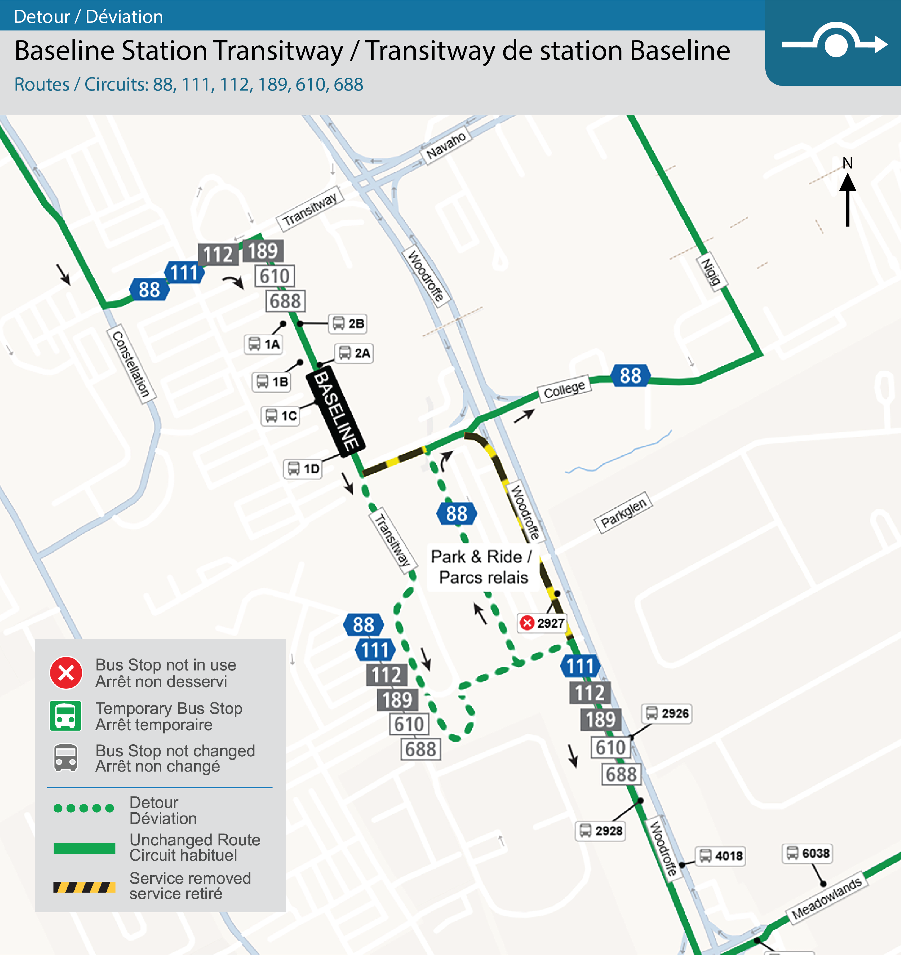
Detour: Baseline Station Transitway
Routes: 88, 111, 112, 189, 610, 688
Date effective: March 20, 2026
From 5:00 am on Friday, March 20, until 6:00 pm on Tuesday, May 26, the southbound left turn from the Transitway to College Avenue at Baseline Station will be closed.
Routes 88 Hurdman, 111 Billings Bridge, 112 Billings Bridge, 189 Colonnade, 610 St. Pius, and 688 Merivale H.S. will detour around the Park & Ride lot before continuing on their regular routes.
Detour routing
88 Hurdman: From the southbound platform at Baseline Station, continue south toward layup, keep right, continue around loop toward Woodroffe, follow Transitway north, right onto Transitway, continue across Woodroffe to College Ave / Adjidjàk Private.
111 Billings Bridge, 112 Billings Bridge, 189 Colonnade, 610 St. Pius, 688 Merivale H.S.: From the southbound platform at Baseline Station, continue south toward layup, keep right, continue around loop toward Woodroffe, right onto Woodroffe to regular route.
Detour map
Detour: Route 87 during Woodroffe Avenue closure (Byron/Richmond to Kichi Zibi Mikan)
Routes: 87
Date effective: March 29, 2026
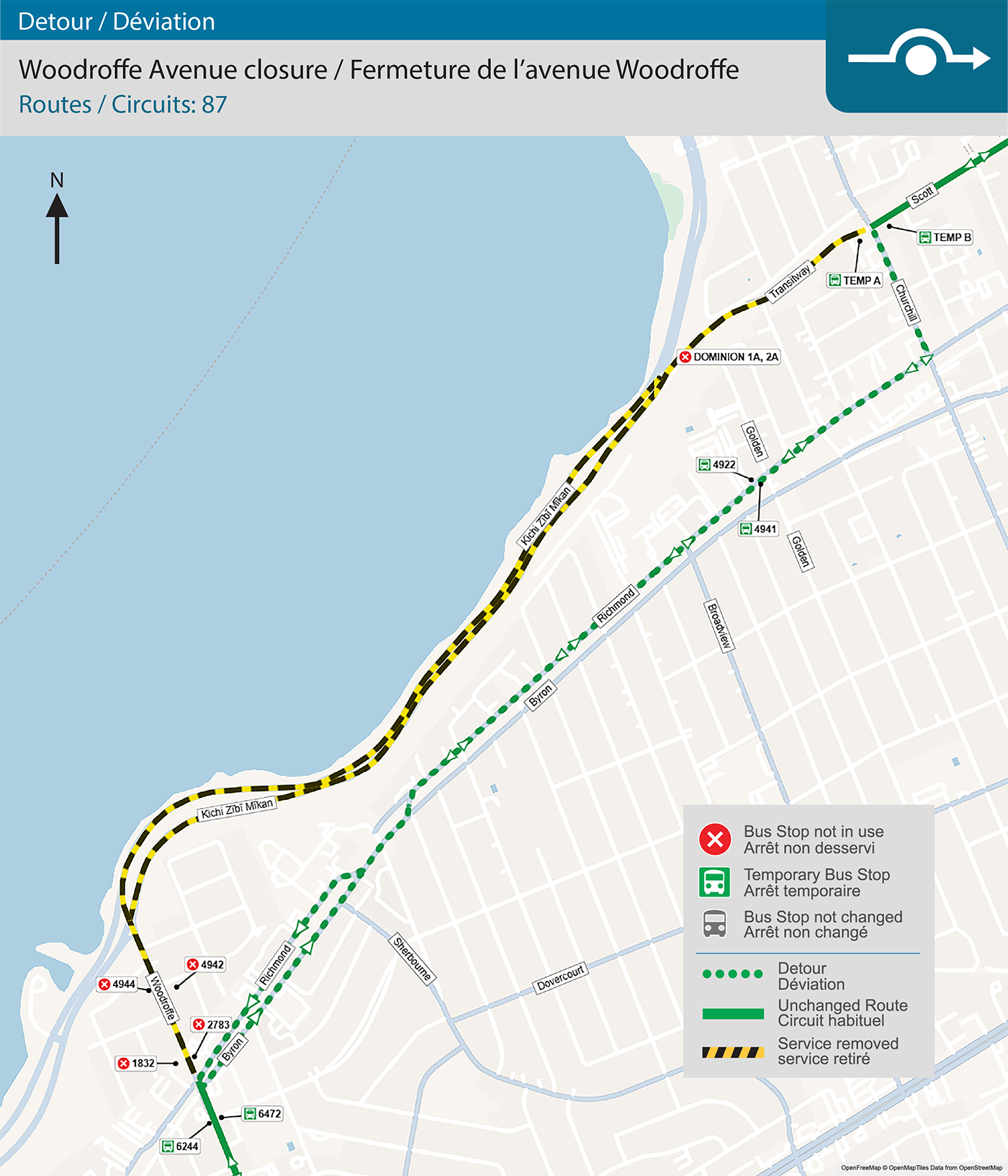
From 8:00 pm on Sunday, March 29, until 11:59 pm on Monday, August 10, Woodroffe Avenue will be closed between Byron Avenue/Richmond Road and Kichi Zībī Mīkan for sewer and watermain work, as well as electrical and paving work.
Route 87 will detour in both directions along Richmond between Churchill Avenue and Woodroffe, bypassing Dominion Station, before continuing on its regular route.
Please allow extra time for your travels.
Affected stops
| Bus Stop (560#) not in use | Routes | Alternate Stop |
|---|---|---|
| #4944 -- Woodroffe / Saunders |
|
#6244 -- Woodroffe / Knightsbridge |
| #1832 -- Woodroffe / Richmond | ||
| #4942 -- Woodroffe / Saunders |
|
#7515 -- Richmond / Woodroffe |
| #2783 -- Woodroffe / Richmond | ||
| #3013 -- Dominion 1A |
|
#4922 -- Richmond / Golden OR TEMP A -- Churchill / Scott |
| #3013 -- Dominion 2A |
|
#4941 -- Richmond / Golden OR TEMP B -- Churchill / Scott |
Detour routing
87 Tunney's Pasture: From Woodroffe and Byron, turn right onto Byron, continue on Richmond, left onto Churchill, right onto Scott to regular route.
87 Baseline: From Scott, turn left onto Churchill, right onto Richmond, continue on Byron, left onto Woodroffe to regular route.
Detour map
Detour: Route 51 (Clare Street eastbound lane closure)
Routes: 51
Date effective: March 23, 2026
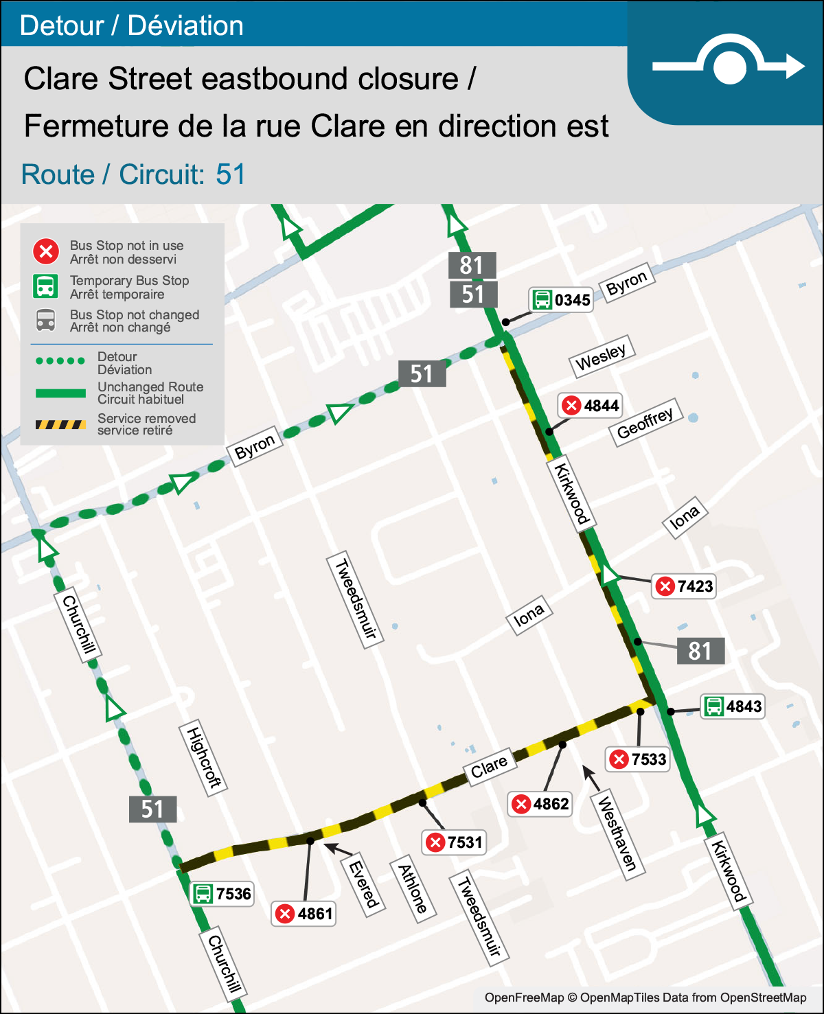
From 6:00 am on Monday, March 23, until 6:00 pm on Tuesday, December 1, the eastbound lanes of Clare Street, between Churchill Avenue and Kirkwood Avenue will be closed to support the Clare & Dovercourt Integrated Renewal Project.
As a result, route 51 Tunney's Pasture will detour along Churchill and Byron Avenue before continuing onto the regular route at Kirkwood.
Please allow extra time for your travels.
Affected stops
| Bus Stop (560#) affected | Routes | Alternate Stop |
|---|---|---|
| #4861 -- Clare (south-side) / Evered |
|
#7536 -- Churchill (east-side) / Clare |
| #7531 -- Clare (south-side) / Tweedsmuir | ||
| #4862 -- Clare (south-side) / Westhaven | #4843 -- Kirkwood (east-side) / Clare | |
| #7533 -- Clare (south-side) / Kirkwood | ||
| #7423 -- Kirkwood (east-side) / Iona |
|
#0345 -- Kirkwood (east-side) / Byron |
|
No change to service | |
| #4844 -- Kirkwood (east-side) / Geoffrey |
|
#0345 -- Kirkwood (east-side) / Byron |
|
No change to service |
Detour routing
51 Tunney's Pasture: From Churchill northbound, continue Churchill, right onto Byron, left onto Kirkwood, continue regular route.
Detour map
Permanent route change: 621 and 698 serving Ottawa high schools
Routes: 698
Date effective: March 02, 2026
Starting March 2, service on school routes 621 and 698 will be withdrawn or modified. Affected schools have notified the students impacted by these changes with details on alternative service.
Students can use the Travel Planner to plan their trip on OC Transpo buses, or visit the Ottawa Student Transportation website for information on yellow school bus service.
Route 621
- All trips on this route will be removed
- Transportation to Lester B. Pearson High School and Gloucester High School will be provided by yellow school bus going forward
- Service to Colonel By High School is available with OC Transpo regular bus service
Route 698
- Trips serving St Patrick’s High School will be shortened to no longer operate east of Conroy Road
- Service east of Conroy Road will be replaced by yellow school bus service
- The trip starting at Blohm / Forestglade at 7:40 am will be removed
- One of the trips departing St Patrick’s High School at 2:44 pm will be removed
- The remaining three morning and three afternoon trips are expected to provide sufficient capacity
- These changes do not impact Route 698 service for Ridgemont High School
DETOUR: 168 Hope Side extension to Stonehaven
Routes: 168
Date effective: February 16, 2026
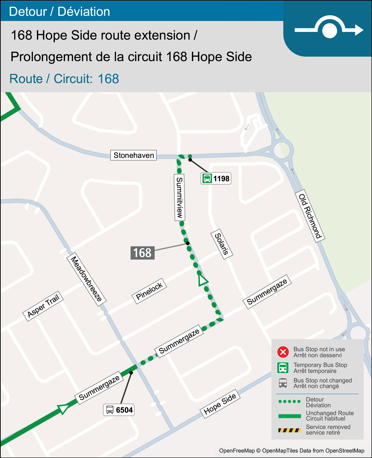
From February 16 until April 18, route 168 Hope Side will be extended from Acceptance to Stonehaven. A new stop for this route will be added, #1198 -- Stonehaven (south-side) / Summitview.
Detour routing
168 Hope Side: From Meadowbreeze, continue on Summergaze, left onto Summitview, right onto Stonehaven, end trip at Stonehaven and Summitview.
Detour map
UPDATE—Stop impacts: Routes 138, 637, 678 on St-Joseph (Orleans to Jeanne d’Arc)
Routes: 138, 637, 678
Date effective: February 17, 2026
Detour end date updated on March 27, 2026
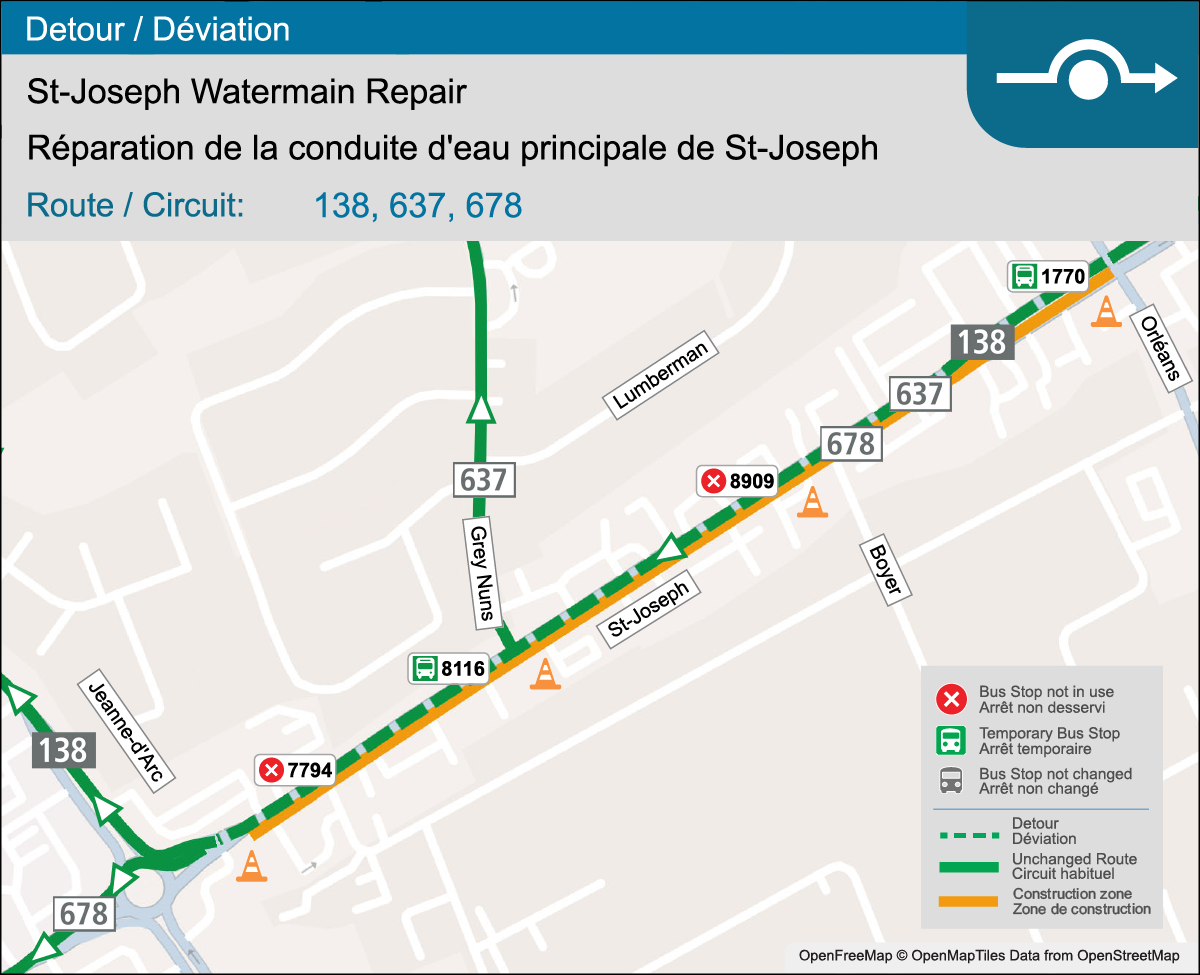
From 7:00 am on Tuesday, February 17, until 6:00 pm on Thursday, April 30, emergency watermain repairs will be made along St. Joseph Boulevard between Orleans Boulevard and Jeanne d'Arc Street.
The work will take place in two phases:
| Phase | Start | End |
|---|---|---|
| 1 | 7:00 am, February 17 | 6:00 pm, March 2 |
| 2 | 7:00 am, February 24 | 6:00 pm, April 30 |
As a result of lane closures, routes 138, 637, and 678 travelling along St. Joseph will need to make alternate stops around the construction areas.
Please allow extra time for your travels.
Affected stops
| Bus Stop (560#) not in use | Routes | Alternate Stop |
|---|---|---|
| #7794 -- St. Joseph (north-side) / Notre Dame |
|
February 17 to March 2 #8116 -- St. Joseph (north-side) / Grey Nuns |
| #8909 -- St. Joseph (north-side) / Boyer |
|
February 17 to April 30 #1770 -- St. Joseph (north-side) / Orleans #8116 -- St. Joseph (north-side) / Grey Nuns |
Map
Service adjustments: Westbound routes 61, 62, 63 (Lincoln Fields to Pinecrest)
Routes: 61, 62, 63
Date effective: January 29, 2026
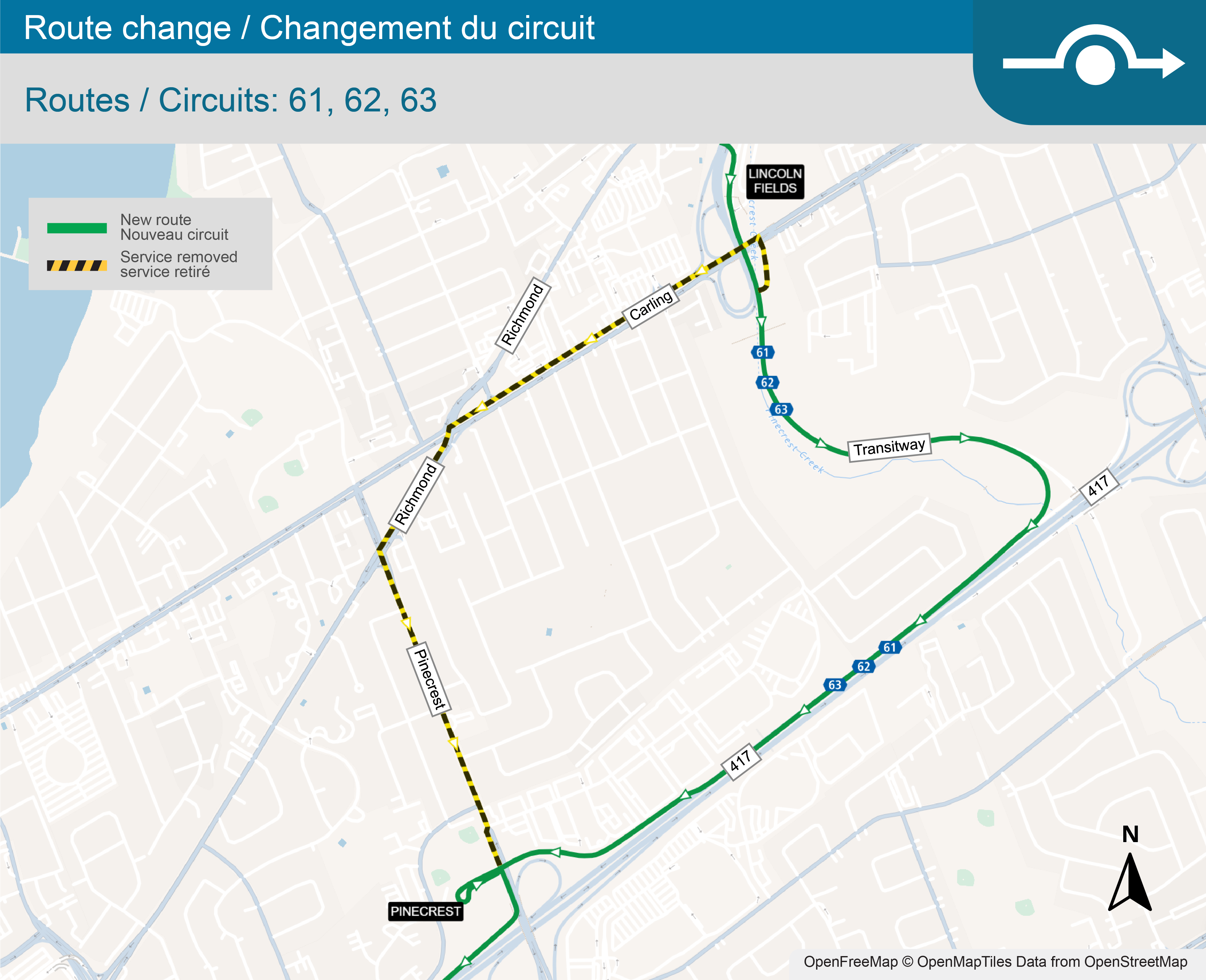
Beginning on Thursday, January 29, routes 61 Stittsville, 62 Stittsville, and 63 Innovation / Briarbrook will be permanently rerouted between Lincoln Fields Station and Pinecrest Station along the Transitway and Highway 417.
There will be no adjustments to these routes in the eastbound direction.
There will be no bus stop impacts.
Detour routing
61 Stittsville, 62 Stittsville, 63 Innovation / Briarbrook: After servicing Lincoln Fields Station, continue southbound on the Transitway, right onto Transitway ramp to Highway 417 westbound, continue on Highway 417, exit at Pinecrest, continue straight into Pinecrest Station, continue to regular route.
Map
UPDATE—DETOUR: Route 90 near Canada Post
Routes: 90
Date effective: January 06, 2026
Detour end date updated on March 10, 2026
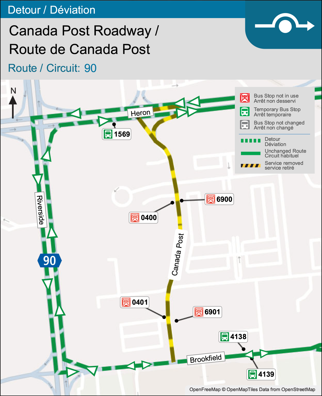
From 7:00 am on Tuesday, January 6, until 6:00 pm on Sunday, May 31, Canada Post Roadway, between Brookfield Road and Heron Road, will be reduced to one lane of travel due to sewer installation on the east side of the road.
As a result, route 90 will detour in both directions along Riverside Drive.
Please allow extra time for your travels.
Affected stops
| Bus Stop (560#) not in use | Routes | Alternate Stop |
|---|---|---|
| #6901 -- Canada Post (east-side) / Brookfield |
|
#4138 -- Brookfield (north-side) / Hobson |
| #6900 -- Canada Post (east-side) / Heron |
|
#1569 -- Heron (south-side) / Riverside |
| #0400 -- Canada Post (west-side) / Heron |
|
#4139 -- Brookfield (south-side) / Hobson |
| #0401 -- Canada Post (west-side) / Brookfield |
Detour routing
90 Hurdman: From Brookfield westbound, continue Brookfield, right onto Riverside,right onto Heron, continue to regular route.
90 Greenboro: From Heron westbound, continue Heron, left onto Riverside,left onto Brookfield, continue to regular route.
Detour map
UPDATE—Detour: Hillcrest High School driveway loop closed
Routes: 649
Date effective: October 20, 2025
Detour end date updated on February 3, 2026
From 6:00 am on Monday, October 20, until further notice, the Hillcrest High School driveway loop will be closed due to construction.
As a result, route 649 Hillcrest will be detoured to drop students off at the departure stop (#8498 -- Dauphin / Tweed) in front of the school.
There will be no other service impacts.
Detour routing
649 Hillcrest: From Haig northbound at Pleasant Park, left onto Pleasant Park, right onto Lynda, right onto Smyth, right onto Dauphin, end trip in front of school at stop #8498 -- Dauphin (west-side) / Tweed.
Detour: Carling and Merivale (Phase 4), route 85
Routes: 85
Date effective: September 29, 2025
From 3:00 pm on Monday, September 29, until late fall 2025*, roadwork at the Carling Avenue and Merivale Road intersection will close some eastbound and westbound lanes on Carling, and reduce southbound lanes on Merivale.
As a result, some bus stops will be temporarily relocated during this period.
Please allow extra time for your travels.
*Completion date to be determined.
Affected stops
| Bus Stop (560#) not in use | Routes | Alternate Stop |
|---|---|---|
| #7429 -- Carling (south-side) / Anna |
|
TEMP -- relocated to south-west corner of Carling / Stevenson |
| #8094 -- Carling (south-side) / Merivale | TEMP -- relocated to south-east corner of Carling / Merivale |
Detour: Routes entering and exiting Limebank Station
Routes: 70, 73, 74, 99, 110, 198, 283, 299
Stations: Limebank, Limebank
Date effective: August 18, 2025
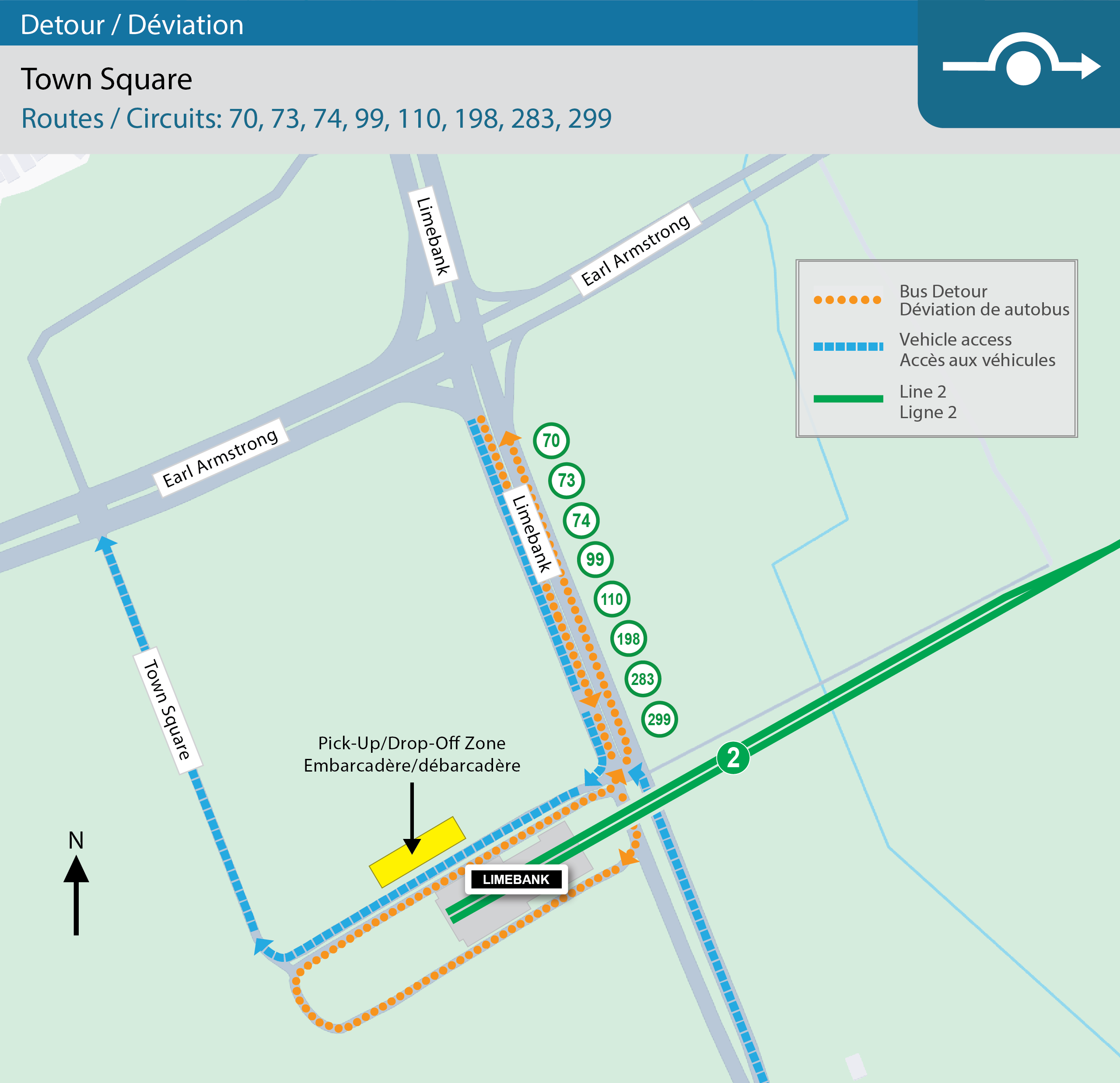
At 10:00 am on Thursday, December 18, Town Square Road and the connector road at Limebank Station will re-open to general traffic. Routes 70, 73, 74, 99, 110, 198, 283, 299 will continue to follow a detour by entering and exiting Limebank Station via Limebank Road, until further notice.
Detour routing
99 Limebank: From Limebank, right onto Limebank Station Bus Only Roadway, Loop around bus loop, right onto Connector Roadway, continue regular route (and regular service stops within Limebank Station).
99 Barrhaven Centre: From Limebank Station, loop around bus loop, right onto Connector Roadway, left onto Limebank, continue regular route.
110 Limebank: From Earl Armstrong, right onto Limebank, right onto Limebank Station Bus Only Roadway, Loop around bus loop, right onto Connector Roadway, continue regular route (and regular service stops within Limebank Station).
110 Innovation: No detour required.
70, 73, 74, 198, 283, 299 Limebank: From Earl Armstrong, right onto Limebank, right onto Limebank Station Bus Only Roadway, Loop around bus loop, right onto Connector Roadway, continue regular route (and regular service stops within Limebank Station).
70, 73, 74, 198, 283, 299 Outbound trips: From Limebank Station, loop around bus loop, right onto Connector Roadway, left onto Limebank, left onto Earl Armstrong, continue regular route.
Detour map
Station layout map

Stop impacts: #2783—Woodroffe / Richmond
Routes: 87
Date effective: June 09, 2025
At the start of service on Monday, June 9 until further notice, bus stop #2783 will not be in use for Stage 2 work. Alternative service will be available at #4942 -- Woodroffe / Saunders or #6472 -- Woodroffe Knightsbridge
Affected stops
| Bus Stop (560#) not in use | Routes | Alternate Stop |
|---|---|---|
|
#2783 -- Woodroffe / Richmond |
|
Detour extended: Promenade du Portage closure (Les Terrasses de la Chaudière)
Routes: 8, 13
Date effective: February 02, 2026
Routes 8 Gatineau and13 Gatineau will be detoured until Friday, June 26, due to the closure of Promenade du Portage between Eddy and Alexandre-Taché for work. Please allow a few extra minutes for your travels.
Affected stops
| Bus Stop (560#) not in use | Routes | Alternate Stop |
|---|---|---|
| #1256 -- Laurier (east side) / Courcelette |
|
STO #2616 -- Portage (south side) / Hôtel-de-Ville |
| #5718 -- Promenade du Portage (north side) / Terrasses de la Chaudière |
|
|
Detour routing
8 Gatineau, 13 Gatineau: From Eddy northbound, right Laurier, left onto Laval, right onto Portage right onto Hôtel-de-Ville, left onto Laurier, and then continue to regular routing.
8 Dow's Lake, 13 Tunney's Pasture: Follow regular routing.
Detour Map

Detour extended: Cheo Roadway closure (1Door4Care)
Routes: 5, 45
Date effective: May 21, 2024
Until further notice, Route 45 Hurdman and 5 will be detoured due to the closure of CHEO Roadway for the 1Door4Care: CHEO Integrated Treatment Centre development. Please allow a few extra minutes for your travels.
Effective April 27, at the start of service
Routes 55 Elmvale and 55 Westgate changed to Routes 5 Elmvale and 5 Waller, respectively.
Affected Stops
| Bus Stop (560#) not in use | Routes | Alternate Stop |
|---|---|---|
|
#1808 -- CHEO Roadway (east side) / Main Entrance |
|
|
|
#7045 -- CHEO Roadway (west side) / Main Entrance |
|
Temporary stop -- Ring (south side) / CHEO Roadway |
Detour Routings
Route 45/ N45 Hurdman & N Rideau: From Ring Road/ CHEO Roadway, continue on Ring Road, right onto Ring Road, and then continue to regular routing.
Route 5 Elmvale: From Ring Road northbound, right onto Ring Road, and then continue to regular routing.
Route 5 Waller: From Ring Road/ CHEO Roadway, continue on Ring Road, left onto Ring Road, and then continue to regular routing.
Detour Maps


Detour: Routes 40 and 693 to St Francis Xavier
Routes: 40
Date effective: April 28, 2025
UPDATE: Route 40 in both directions near Albion, until 8:00PM on May 11, 2026.
40 Greenboro
From Albion, right Rosebella, left Bank Street, left St. Bernard , continue D’Aoust, right Albion to regular route.
Stops missed: ALBION / GOTH - (4265), ALBION / WYLDEWOOD - (4264), ALBION / D'AOUST - (8882)
Alternate stops: QUEENSDALE / ALBION - (8881), ALBION / BRAMPTON - (8951)
40 St Laurent
From Albion, left D’Aoust , continue St. Bernard, right Bank, right Rosebella, left Albion to regular route.
Stops missed: ALBION / CINANNI - (8873), ALBION / WYLDEWOOD - (4261), ALBION / MCMAHON - (4262), ALBION / RIDGEDALE - (4263)
Alternate stops: ALBION / BRAMPTON - (4260), QUEENSDALE / ALBION - (8874)
From Monday, April 28 at the start of service until the start of summer service change, Routes 40 and 693 to St Francis Xavier will be detoured. For more details, please contact admin@ottawaschoolbus.ca
Bus Stop (560#) not in use
- #1530 -- Bridle Path / Crosscut
- #8382 -- Bridle Path / Pimlico
- #1799 -- Bridle Path / Equus
- #8743 -- Bridle Path / Equus
- #4248 -- Bridle Path / Hunter's Point
- #4252 -- Bridle Path / Hunter's Point
- #4249 -- Bridle Path / Trapper's
- #4253 -- Bridle Path / Saratoga
- #4254 -- Bridle Path / Carousel
- #4250 -- Bridle Path / Carousel
- #4255 -- Bridle Path / Carousel
- #4251 -- Bridle Path / Albion
Detour routing
40 (school trips only) South Keys: From Albion, left onto Bank, left onto Hunt Club, continue regular route.
40 (school trips only) Blossom Park: From Hunt Club, right onto Bank, right onto Albion, continue regular route.
693 St Francis Xavier: From Albion, left onto Bank, left onto Hunt Club, continue route.
693 Blossom Park: From Hunt Club, right onto Bank, right onto Albion, continue route.
Detour: Elgin Street closure
Routes: 5, 18
Date effective: April 24, 2024
Until further notice, Routes 5 Waller and 18 St-Laurent will be detoured due to the closure of Elgin Street between Catherine to Argyle for work. Please allow a few extra minutes for your travels.
Affected Stops
| Bus Stop (560#) not in use | Alternate Stop |
|---|---|
|
#2466 -- Argyle (east side) / Elgin |
Temporary stop -- Catherine (north side) / Elgin Temporary stop -- Argyle (south side) / Elgin |
Detour Routing
5 Waller, 18 St-Laurent: From Elgin and Pretoria, continue onto Elgin, left onto Catherine, right onto Metcalfe, right onto Argyle, left onto Elgin to regular route.
Stations & Elevators
Public washrooms: Bayshore Station
Stations: Bayshore
Date effective: March 23, 2026
The men’s public washrooms at Bayshore station are currently unavailable. We apologize for the inconvenience.
Place d’Orléans Station: Bus stop changes
Stations: Place d’Orléans
Date effective: February 24, 2026
On Tuesday, February 24, the bus stops at Place d'Orléans Station will be converted from numbers to letters.
Signs and wayfinding information will be updated to reflect these changes.
There will be no changes to route schedules or where your route physically stops. See the Place d'Orléans station page for details.
Station map

Line 1 public washrooms
Stations: Bayview, Bayview, Blair, Blair, Hurdman, Hurdman, Tunney’s Pasture, Tunney’s Pasture
Date effective: February 20, 2026
All public washrooms on Line 1 are temporarily closed due to vandalism. Thank you for your patience
Stop Impacts: Bayshore Stop A & B Relocation
Routes: 57, 58, 61, 62, 63, 81, 85, 404, 406
Stations: Bayshore, Bayshore, Bayshore
Date effective: February 01, 2026
Until further notice, Bayshore Stop B and Stop C will be located on the north side of the platform. Bayshore Stop A will also be temporarily relocated to the south side of the platform.
All routes will be serving Bayshore Station, during this time. This adjustment is to allow for Stage 2 work. For assistance, contact us.
Limebank Station: Passenger pick-up and drop-off area relocation
Stations: Limebank
Date effective: December 18, 2025
At 10:00 am on Thursday, December 18, Town Square Road and the connector road at Limebank Station will re-open to general traffic. As a result, the temporarily-relocated passenger pick-up and drop-off zone will be moved back to its original location, on the north side of Limebank Station.
Customers are reminded to use the designated pedestrian crossing zones when travelling between the O-Train station and the passenger pick-up and drop-off area.
Routes 70, 73, 74, 99, 110, 198, 283, 299 will continue to follow a detour by entering and exiting Limebank Station via Limebank Road.
Detour routing
99 Limebank: From Limebank, right onto Limebank Station Bus Only Roadway, Loop around bus loop, right onto Connector Roadway, continue regular route (and regular service stops within Limebank Station).
99 Barrhaven Centre: From Limebank Station, loop around bus loop, right onto Connector Roadway, left onto Limebank, continue regular route.
110 Limebank: From Earl Armstrong, right onto Limebank, right onto Limebank Station Bus Only Roadway, Loop around bus loop, right onto Connector Roadway, continue regular route (and regular service stops within Limebank Station).
110 Innovation: No detour required.
70, 73, 74, 198, 283, 299 Limebank: From Earl Armstrong, right onto Limebank, right onto Limebank Station Bus Only Roadway, Loop around bus loop, right onto Connector Roadway, continue regular route (and regular service stops within Limebank Station).
70, 73, 74, 198, 283, 299 Outbound trips: From Limebank Station, loop around bus loop, right onto Connector Roadway, left onto Limebank, left onto Earl Armstrong, continue regular route.
Maps (effective December 18)
Stop impacts: Blair Station stop I relocation (UPDATED)
Routes: 12, 15, 23, 24, 26, 42
Stations: Blair
Date effective: October 14, 2025
Updated on Friday, February 27, 2026
From 11:00 am on Tuesday, October 14 and continuing through fall 2026*, stop I at Blair Station will be temporarily closed. This closure is due to construction work being performed on the north bus platform, as part of the Blair Station Elevator Replacement Project.
Impacts
- Service for routes 12, 15, 23, 24, 26, 39, N39, and 42 will be relocated two stops east to stop G during the work period.
- No pedestrian access to north bus platform from the west side of the station. Use the accessible walkway along north platform East.
- No impact to north bus platform elevator or stairs
What else to expect
Customers should expect a heavier presence of construction activity along the pedestrian walkway at the station.
Starting March 2, 2026, part of the north bus platform and the lower level east doors will be closed for several months to allow work on the new elevator system. Customers will use the adjacent south doors to access stops F, G, and H using a temporary platform installed next to the existing platform. This will not affect the stop locations or service.
Other minor impacts to platforms and walkways on certain workdays may occur. Construction crews and flaggers will guide customers as required.
*Date to-be-confirmed
Affected stops
| Bus Stop (560#) not in use | Routes | Alternate Stop |
|---|---|---|
| #3027 -- Blair I |
|
#3027 -- Blair G |
Stop relocation map

Stop impacts: Mackenzie King Bridge A and B
Stations: Mackenzie King
Date effective: July 11, 2025
From July 2025 until July 2026, Mackenzie King Bridge stops A and B will be temporarily moved slightly east to accommodate road work.
There will be no bus route impacts.
Service Impact: Baseline Station Park and Ride – Temporary Lot Configuration
Stations: Baseline
Date effective: May 01, 2025
Starting Thursday, May 1, 2025, until further notice, the Park and Ride at Baseline Station will be temporarily split into two separate lots (north and south). All gold permit holders and accessible stalls will be located in the north lot, standard parking spaces will be available in the south lot.
Stop impacts: Bayview B
Stations: Bayview
Date effective: December 03, 2024
Until further notice, Bayview B will be relocated to Scott Street (south side) / Bayview station Road for work. Please allow a few extra minutes for your travels.
Alternate stops
| Bus Stop (560#) not in use | Alternate Stop |
|---|---|
|
Bayview B |
Temporary stop -- Scott Street (south side) / Bayview station Road |
Stop impact map

Relocation notice: Trim Station bus loop
Stations: Trim
Date effective: September 22, 2024
On Sunday, September 22 at 4 am, the current Trim Station will be permanently relocated to the new Trim Station Bus Loop due to the closure of of South Frontage between Old Trim and New Trim Road, in addition to the southern parts of the Park and Ride lot for Stage 2 work. Please allow a few extra minutes for your travels.
Park & Ride impacts
The most southern Park and Ride lot will be closed. Please park in the open areas of the parking lots.
Pedestrian access instructions
Pedestrian access into the station is available at the east side of the station along New Trim Road.
Pedestrian access will also be available within the Park and Ride itself to the new bus platforms.
Affected stops
| Bus Stop (560#) not in use | Routes | Alternate Stop |
|---|---|---|
|
#3029 -- Trim 2A |
|
Trim 2A in new bus loop. |
| #3029 -- Trim 1A |
|
Trim 1A in new bus loop. |
Detour routing
38 Blair: Start route in new Trim Bus Loop at service stop 2A, continue to east exit to New Trim Road, left onto New Trim Road, continue regular routing
38 Jeanne d’Arc/Trim: From New Trim Southbound, right onto Eastern access to New Trim Station, continue to service stop 1A, end route
39 Blair & N Rideau: Start route in new Trim Bus Loop at service stop 2A, continue to east exit to New Trim Road, left onto New Trim Road, continue regular routing
39 Millennium: From OR174 Eastbound, exit Trim Road, remaining in the left lane, proceed to intersection of Trim EB Off-ramp and Old Trim Rd, left onto Western access to Trim Station, continue to service stop 1A, continue to east exit to New Trim Road, right onto New Trim Rd, continue to regular routing
221 Blair: From Old Trim/South Frontage, continue Old Trim northbound to western access to new Trim Bus loop, continue to service stop 2A, continue to east exit to New Trim Road, left onto New Trim Road, continue regular routing
221 Cumberland: From OR174 Eastbound, exit Trim Road, remaining in the left lane, proceed to intersection of Trim EB Off-ramp and Old Trim Rd, left onto Western access to Trim Station, continue to service stop 1A, continue to east exit to New Trim Road, right onto New Trim Rd, continue to regular routing
639 Gisele Lalonde: From Southbound New Trim, right onto East access to Trim Station, continue to service stop 1A, continue to western roadway to Old Trim Southbound, continue Trim SB on regular routing
639 Place d’Orléans: From Old trim Northbound, continue NB Trim To Trim Station, continue to service stop 2A, continue to east end of Trim Station, left onto New Trim, continue regular routing
405 Canadian Tire Centre: Start route at service stop 2A in New Trim Bus Loop, continue to east exit, left onto New Trim Rd, continue regular routing
405 Trim: From OR174 Eastbound, exit Trim Road, remaining in the left lane, proceed to intersection of Trim EB Off-ramp and Old Trim Rd, left onto Western access to Trim Station, continue to service stop 1A, end route
455 Lansdowne: Start route at service stop 2A in New Trim Bus Loop, continue to east exit, left onto New Trim Rd, continue regular routing
455 Trim: From OR174 Eastbound, exit Trim Road, remaining in the left lane, proceed to intersection of Trim EB Off-ramp and Old Trim Rd, left onto Western access to Trim Station, continue to service stop 1A, end route
Permanent relocation: Westboro A
Stations: Westboro
Date effective: September 29, 2024
Permanent relocation
On Sunday, October 6 at 4:00 am, Westboro A will be relocated to the west of Athlone, across from Westboro B for Stage 2 construction. Please allow a few extra minutes for your travels.
Affected stops
| Bus Stop (560#) not in use | Alternate Stop |
|---|---|
| Westboro A |
Relocated to the west of Athlone, across from Westboro B |
Detour routing
No detours will be required.
Relocation notice: Jeanne d’Arc Park and Ride
Stations: Jeanne d’Arc
Date effective: August 19, 2024
From the week of Monday, August 19 until further notice, Jeanne d’Arc Park and Ride will be relocated to accommodate skatepark construction.
During this time, Jeanne d'Arc Park & Ride permit holders are asked to park in other open parts of the parking area surrounding the Bob MacQuarrie Recreation Compex building.
Thank you for your cooperation. We apologize for any inconvenience this may cause.